home » news » authorities » Australia » Victoria
That fallen wall - part 2
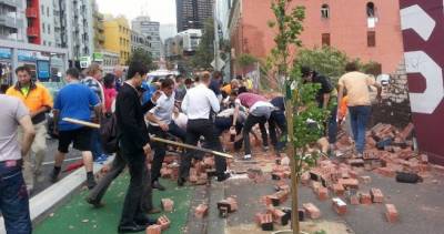
A week ago three people died while they were walking down Swanston Street. One was a French research fellow at Monash. The other two were a young brother and sister on their way to the footy. I published a post about the wall that collapsed on Sunday, gathering together what I could find from publicly available web pages. I didn’t expect the level of reaction I got. I was contacted by all sorts of mainstream media outlets, many in search of speculative comment. My investigations were made not because I consider myself an expert in walls and wind, but because I knew how to do it relatively quickly, and because I wanted to do something.
This was an accident of the “waiting to happen” variety. No one wanted it to happen, but no one seems to have done anything to prevent it happening either. The organisations involved, the way they interact, and the regulations governing them all, could do with some improvement. But conclusions should be left to the inquiries. We should be watching these inquiries, demanding an independent one, and making sure they have all the information they can get to work with.
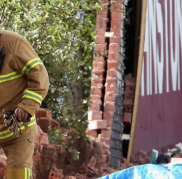
On Thursday I happened to pass the site again. Once again it had altered. A bulldozer was scraping up the debris while a man hosed the dust down. A WorkSafe officer was taking photos of what remained of the footings. A group of random people were gathered at the makeshift shrine, paying their respects .
Here are some further observations about the wall – they aren’t conclusions. The previous post is here.
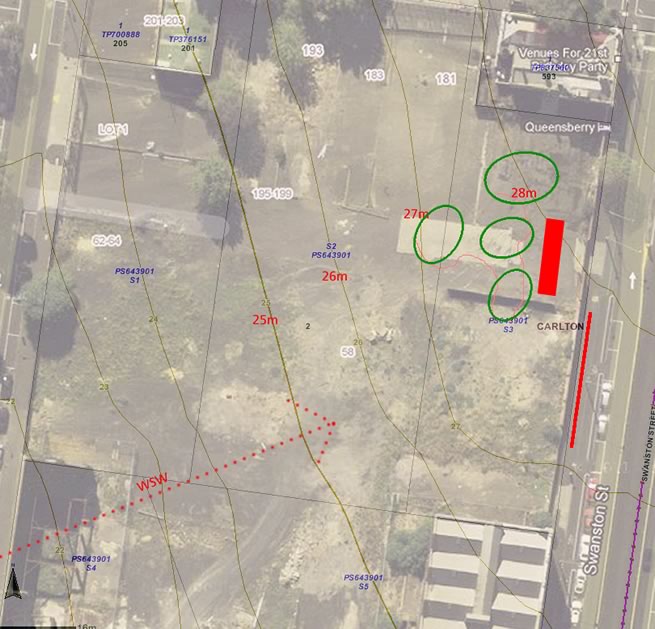
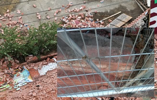
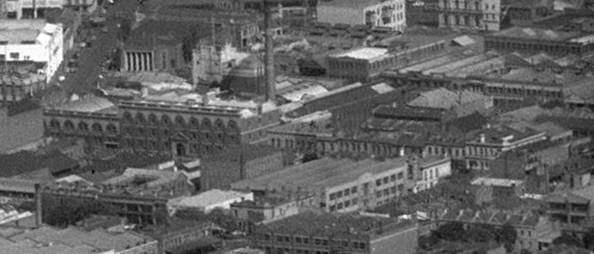
Overlay showing ground (2009), contours, approximate wind direction, and approximate positions of the collapse (red line), the mounds on March 28 (green ellipses – about 1.5m high), and the 7.2m high stacked containers.
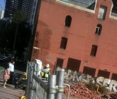
The billboard and the brick wall
Wall from North East ( Red_Baron_012 )
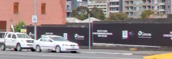
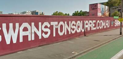
The red hoarding was built in October 2011, after a rebranding of the development by Cornwell from ‘Portrait’ to ‘Swanston Square’. WorkSafe visited the hoarding on October 12th to inspect the installation, following up concerns about the lack of a pedestrian management system. NEWS
The height of the brick wall was about 2.5 to 2.7m on the street side, depending on where you count bricks. The hoarding extended above the wall by about 250 to 500mm. It varied as the top of the hoarding was sloping while the brick wall stepped down the hill at intervals. The land drops by about two metres across this 78 metre street frontage.
Rear view, January 2013. (supplied by R.Liao)
The bricks composing the wall were of two types – extruded “wire-cut” bricks with hollow perforations, and older pressed bricks stamped with “CITY BRICKS”. City Bricks, now absorbed into Boral, had been pressing bricks since 1923. This mixing of bricks suggests that the wall could have been built from recycled bricks of varying ages, compressive strengths, and abilities to withstand moisture.
The freestanding wall had piers at about four metre intervals along the rear side, which might have been useful buttressing against winds off Swanston Street. [ design guide PDF ] But these piers were not reinforced or tied into a footing, and were much wider (2 bricks) than they were deep (half a brick). It might be more appropriate to call them decorative pilasters, making the wall look more substantial than it actually was. The outer skin of the wall was apparently not bonded to these piers at all. A photo shows how one pier failed in the gust of wind.
Left: View from apartment block across street (crop). ( Meld Magazine / A. Ngo) Right: North end of wall – pier imprint on odd concrete upstand – perhaps this predated the brick wall? Also shows that the bricks continuing down in front of the wall were in direct contact with the concrete. (PJ)
These ‘piers’ ‘supported’ twin-leaf wall panels with all bricks laid in the same direction. There was no cavity between the two leafs at their base, though there appeared to be a small one further up. This could have allowed the internal faces of the bricks to trap damp lower down.
Possible cavity or bowing showing in distorted telephoto image, March 28th ( Herald Sun / H.Blair )
The Southern end of the wall ended at one of these piers. This pier once abutted a rickety timber paling fence. In late 2011 this fence was replaced with a new steel one for the red hoarding. This new fence appears to have butted into the brick wall, and may even have been supported by it as not much else appears to have been holding it up. The hoarding was fixed to both the new fence and the wall, so any wind load placed on the elastic lightweight wall could have transfered to the rigid brick wall through the hoarding. This has been covered in the comments below the first post, and since by media.
Left: Southern end of brick wall abutting lightweight hoarding. There is a noticeable bow in this pier, but this could be lens distortion. The horizontal member of the lightweight fence appears to be fixed to the top of the pier. ( Herald Sun / Jem Richardson ) Right: Metal framing of lightweight wall where it abutted the Southern brick pier (ADL NOW / Alex Coppel)
Another photo showing the lack of support at the North end of the lightweight hoarding. The supporting steel post is to the right. (ADL NOW / Alex Coppel)
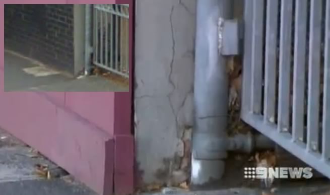
North end of wall (9 News). Much blurrier inset: Google 2009
On March 28th, a 9News bulletin panned over a vertical crack visible at the North end of the remaining wall, without comment. News Ltd has also found photos of diagonal cracking along the rear of the southern portion of wall. News Ltd found this shocking, but as the wall had no control joints or reinforcement, probable moisture problems, and.. who knows what in the way of footings, it’s hard to be surprised. News Ltd’s photos also show black matter at the base of the Southern wall segment. Hopefully this was a damp proof course (which I can’t see anywhere else) and not some kind of mould. From the Swanston Street side, there is also black staining visible on the internal face of the wall which does look more like a mould colony, indicating rising damp.
TOP: Black stuff? December 2012 (Herald Sun / Jes Richardson) BOTTOM: Swanston street side, March 28 (SBS/AAP)
At the Northern end of the collapse, there is a suggestion of what may have prevented the collapse from continuing further. A sliding gate rail is fixed into the wall at the point the collapse stopped. Then again, the fixing may have caused cracking, weakening the wall so that it failed at this point.
Northern extent of wall collapse, showing rusted door rail and fixing ( ADL NOW )
This part of the wall also seemed to have succumbed more to mortar problems than elsewhere. The front face of the wall showed efflorescence between the paint-sealed bricks, and the local pier, taller than the others, was quite uneven and looks to have eroding mortar. The end capping piece is an extruded brick on end, allowing water to penetrate with ease.
Left: Google Street View 2009 showing pier at Northern end of failure. Right: Northern end of failure, 2010. ( twitterpic by @funkineering )
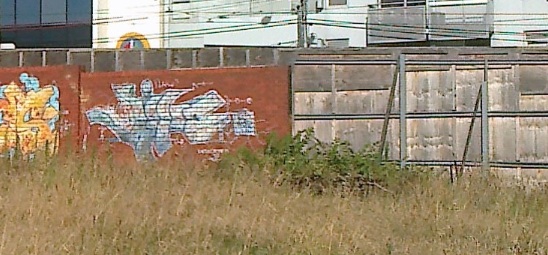
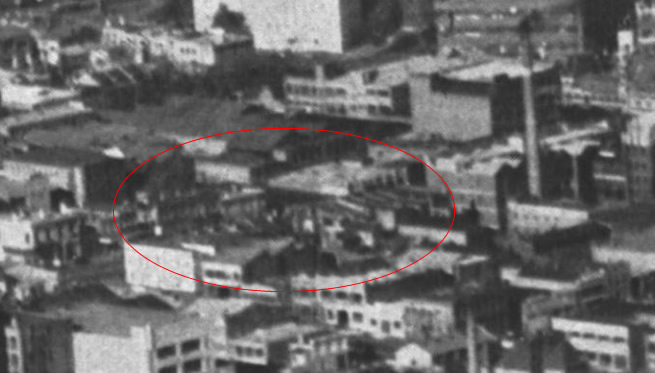
Until 2012 the brick wall was partly shielded from Westerlies by a mound of earth and overgown grasslands. This was replaced with a much larger mound in February, after the overburden scrape. By March 28th, all mounds had been shifted and the area was flat. Clear new photos showing the location of this mound last December, and the nature of the land around it, have been sent in by Rita Liao.
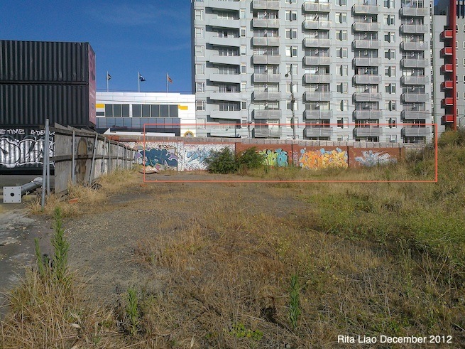
Rear of wall, January 2013, affected area in rectangle. This also shows the asphalt and fencing that were removed in March. (R.Liao / butterpaper)
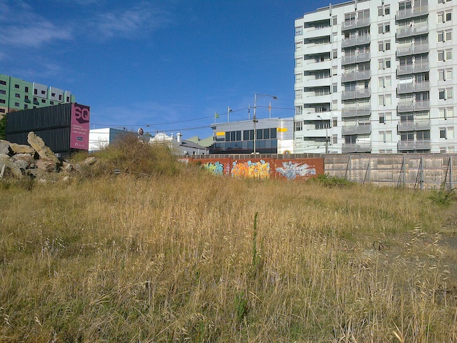
Rear of wall, January 2013, taken from beside the malt house (R.Liao / butterpaper)
A photo at Flickr shows the mound in 2011. (AR Wurster ). Another at the Herald Sun shows it there in 2008.
Some time after 1967, a brick wall was built from the Queensberry Hotel right along to the remaining two terraces (557-561 Swanston Street, but shown as 45-47 Madeline St in the plan below). Terrace houses used to stretch the whole way up to the Queensberry Hotel, but had been gradually done away with bu CUB. A timber fence later replaced the two last buildings, which were demolished soon after the brewery closed. The removal of these buildings exposed the end of the wall to the elements and removed a boundary wall that may have been acting as a return.
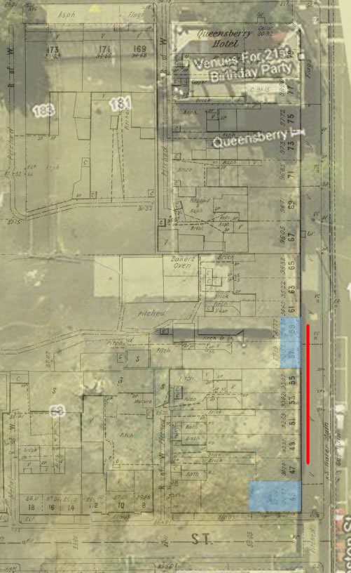
1896 MMBW plan overlaid on Google map, red line showing collapse area, blue shaded areas indicating 19th Century cellars. (SLV)
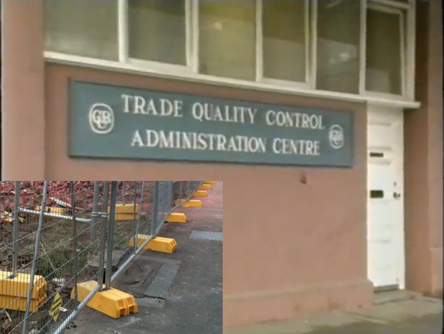
Trade Quality Control Office, at 557 Swanston Street, shown as 45 Madeline Street in the map above. This building contained an 8 foot deep cellar. The doorstep and the bluestone pavers in front of this office at the right of this photo still exist. (1987 CUB video, 2013 PJ)
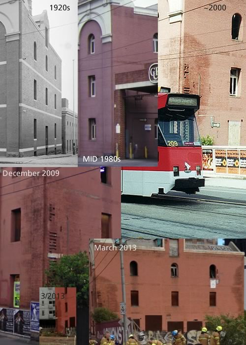
Here are some further images plotting this part of the street through the ages.
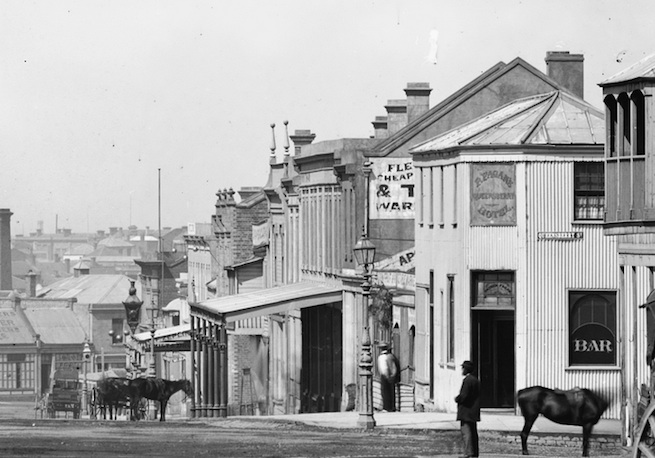
A view from the north c.1870s. Patrick Fagan’s Queensberry Hotel is on the right and buildings along the line of the wall are to the left of the hotel. (SLNSW )
Swanston Street in 1938, with the Queensberry Hotel at the right. Terrace occupants included residents and a diverse set of businesses: the Swanston Battery Service, a Chinese herbalist, a silver-plater, the Maternal and Infant Welfare Division, the Air League headquarters, Peter Kaye’s appliance shop, and the CUB Personnel office at No. 561. ( SLV / Lyle Fowler )
Aerial photograph from 1946 showing two storey terraces the length of the frontage. ( SLV / Lyle Fowler )
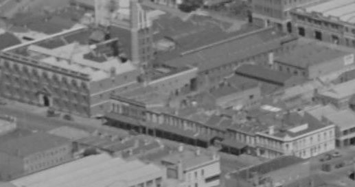
A 1952 aerial view from the North East. ( SLV )
1953 aerial from the North West ( SLV )
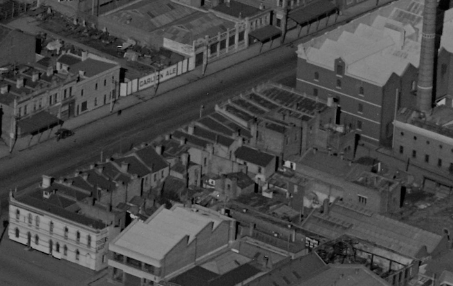
Buildings adjacent to Ballarat Street & Malt Store, 1963. At the time, these buildings at 557 – 561 were used by the Manufacturers Bottle Co. ( SLV / Lyle Fowler )
Here’s a low-res 1968 aerial photo , and another from the year after.
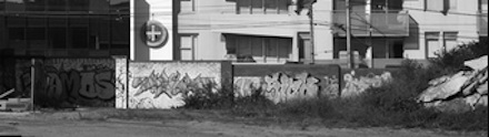
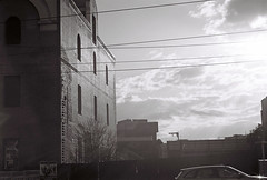
To date, this is the only photo I can find of the wall prior to the demolition of the brewery, taken in 1979 and showing the “top yard” behind the wall and the buildings at the South. This is the blurry online version. ( NLA: Wolfgang Sievers ).
The Malthouse
The adjacent malthouse has been in a state of neglect for decades. Built in 1904 and out of use since at least 1987, it too has moisture problems. Moisture is trapped and spreading behind the paintwork added some time before 1988. Demolition of the abutting pier in 1989/90 without any remedial work didn’t help things. I hope that the deteriorating condition of this building is quickly examined in case it too poses a risk to passersby.
Water penetration at the Malt Store
The Brewery
The first brewery on the site was established in 1858. In 1907 a merger of six breweries formed Carlton & United Breweries who then operated from the site. Numerous owners performed building works on the site over its 129 years of production.
The brewery was used only for keg production after 1949, and was closed in 1987. A three part video documents the closure, which makes reference to an outdoor ‘top yard’ used for empty keg deliveries. It had an entry from Swanston Street. From a process of elimination, I’m assuming this to be the yard behind the fallen brick wall.
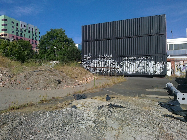
Rear of wall and ad containers, showing old asphalt, now removed. January 2013 (R.Liao / butterpaper)
The authorities
The Australian asserts that there is a “squabble” between the City of Melbourne (CoM) and the Ministry for Planning over who is responsible for the wall. It comes down to a matter of definition – whether the wall is a free-standing hoarding (ministry resposibility), or a street advertisement (council). This wall is both.
The Minister says he didn’t approve the hoarding, and the council was “unable to locate paperwork relating to any application”. The Australian believes the council approved the immediate demolition of the rest of the wall. LINK
In its report of 14/03/13, Heritage Victoria list what is included within the site’s heritage registration.
- 1. All the buildings known as the former Carlton and United Brewery buildings B1 and former Malthouse B2 marked on Diagram 26 held by the Executive Director.
- 2. All the land marked L1 on Diagram 26 held by the Executive Director, being part of the land described in Certificate of Title Vol. 7620 Fol. 130 and Vol. 4617 Fol. 290.
On Tuesday 2nd April, City of Melbourne issued a press release stating that would not comment further, “at this time”. CoM
More wall zone photos through the decades
This section will be updated as any new photographs are found. The photos at the linked Flickr pages can be clicked on to see much larger versions.
2000?
- Southern end of hoarding – white and about 1.8m high. Incorrectly dated. Flickr
2006
- Black paling fence at south end Flickr
2007
- Photo showing glimpse of rear of timber fence at South. FLICKR
2008
- Black wall walking video
2010
- Southern timber fence from street (part). FLICKR
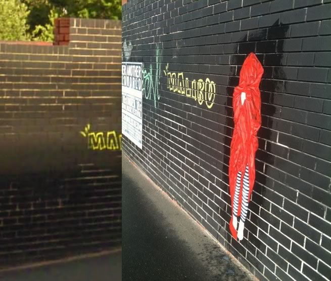
- September: More photos of the red-shrouded woman (by artist urban cake lady) pasted to the wall. View full size for extreme close-ups of the Eastern brickwork at North point of collapse. FLICKR1 FLICKR2
- October: Tram ride footage – black brick wall Video
2011
- Rear of timber fence (large). ARTYGRAFFARTI
- ~Early 2011: New livery – a fabric(?) panel. (Google)
- April: Signage: “New City Living Carltonbrewery.com.au”
Flickr - April: “Portrait” signage and stacked containers in place. Click to view.
- November: Red wall just visible. NEWS
- November: Glimpse of rear of wall. FLICKR
- December: News Ltd sources new photos dated December 2012 showing minor cracking on the rear of the some Southern section of the wall. This photo also shows lightweight wall abutting the Southern pier. NEWS 04.04.13
2012
- January: distant aerial video shows pink stacked “SQ” containers. Video
- February: Glimpse of red wall form south. Flickr
- Sept 2012 rear view showing piers and mound. Flickr
2013
- January: Bike-mounted video shows wall clearly. Video
- March 28: Wall collapses at about 3pm.
- March 28: 9News footage shows cracks at Northern end of wall where it abuts the Queensberry Hotel lot. Video
- A good gallery of images taken from the rear side of the wall, immediately after the collapse, is available at Adelaide Now
CUB site development timeline (potted)
1981
- Merger of Elders and Henry Jones (IXL) gives CUB a stake in Elders. NEWS
1983
- Elders buys its shareholder CUB.
1987
- Brewery closes in June.
- Council trades plot ratio concessions for community benefits (60 apartments, underground parking, preservation of historic buildings, a podium to the tower).
- Site rezoned by council.
- Site value jumps.
- Site control taken by Minister for Planning due to importance to state.
- November: Elders Investments buys 25% stake in developers Hudson Conway
1989
- February: Elders IXL / John Elliot’s Melbourne Wintergarden development (architects Perrott Lyon Mathieson), including a 35 storey blue glass office tower wins planning approval from Minister for Planning. A plaza replaced the podium, most parking was above ground, and the apartments were marked “Stage 2”. Council were disappointed and worried that the minister’s takeover of the site set a precedent. NEWS LINK & PHOTO
Architecture graduate Paul Morgan, on behalf of a group, describes loss of podium as “architecturally regressive”. “Responsibility for the symbolic sense of the city has been abrogated by the State Government… The character of the city is being left to the developer and the architect.”
- Hudson Conway’s Lloyd Williams, site developer, denies that there was ever an agreement with council.
- October (Black Monday): Elders delays $400M glass tower NEWS indefinitely
1995
- Pacific Central Development planning application prepared by Ashton Raggatt McDougall architects. DPCD
1998
- RMIT purchases site for $25M. NEWS
2002
- December RMIT prepares to sell, during financial crisis. NEWS
2005
- RCH considers site for new hospital.
2006
- Site on shortlist for new ANZ HQ. NEWS
- October: Grocon buys most of the site for $39M from RMIT. Expects to start $800M development in late 2007. Project architects: NH Architecture. NEWS
2007
- January: Masterplanning working group meetings begin, which include representatives from RMIT, City of Melbourne, DPCD, and the State Government architect, and appearances from Heritage Victoria and National Trust.
- June: Grocon announces competition winners, including ARM & DCM. NEWS
- July: RMIT and Grocon apply to Minister for Planning to prepare an amendment to expedite planning process for this site. DPCD
2008
- March: Minister for Planning Justin Madden exempts himself from notice of amendment clauses of Planning and Environment Act 1987 in respect of this site’s C126 amendment. One reason is that, “the critical timeline for development of the project would not be met through the normal permit application process.” Minister Madden noted at the time that due to the number of agencies involved (DPCD, Heritage Victoria, VicRoads and the City of Melbourne), he would become the “single point of planning approval”. DPCD
- C126 Amendment states: “A permit is not required for: Site preparation and retention works including security fencing, site offices, bulk
excavation and piling, footings, ground beams and ground slabs;…” DPCD - March: Intention to build, archaeological dig NEWS1 NEWS2
- March: Aerial photo. FORUM
- April. From Bouverie Street(?), geotech begins. FORUM
2009
- Design Hub begins construction in September. August photo September video
- Heritage permit issued for site. DPCD
2010
- Kmart to be anchor retail tenant of $1.2B development to start in early 2011.
NEWS - September: Grocons sells apartments despite no planning permit having been approved for building 5 (than called Portrait). NEWS
This post has been continued: PART 3 is here
EDITS: 10/4/13: add new image links, minor corrections, 12/4/13 lens distortion note, 26/5/23 new images.
Posted by Peter on 07.04.13 in authorities
tags: brick, demolition, developers, safety, swanston street wall, wind
comment
Hi again Peter. Great work on this. Keep it up.
A few general thoughts after reading some of your latest updates. Hope these can add to the discussion:
- a cavity? Yikes! Substantially weaker than a solid wall. – mounds and other obstructions can slow the wind but can also accelerate the flow locally – damp can weaken certain types of brick. Particularly if underfired. But.. – a membrane type damp proof course can substantially weaken a wall by providing less friction and less bond than a mortar joint. An over fired, pressed brick can have a very smooth surface, which can also reduce bond.
by Greg Killen on 8 April 2013 ·#
Hi Greg, great to have your struct. engineering input.
I’m not sure that was a cavity – may have been the lens – it didn’t look like one in some other pics but all too far away to properly see.
I was thinking along the lines of a mortar DPC – what was the norm back in the ’70s?
Can the level of firing be gleaned from the darkness of the brick?
P
by peter on 8 April 2013 ·#
Hi Peter, you might be interested to know that archaeological excavation is being carried out at 557-561 Swanston Street at the moment – apparently digging up the buried footings and back yards of the terrace houses along here. It might be an opportunity to add to your extensive analysis of this site and the tragedy that occurred there.
by gary vines on 14 July 2016 ·#
Commenting is closed for this article.
-
 Fait accompli?
27.10.23 in news -
 The wall revisited: bulge
03.04.22 in news -
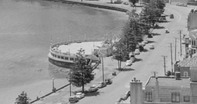 Shifting sands at Oriental Bay
09.11.19 in news -
 Swanston street wall - "Responsible" Authorities
17.08.19 in news -
 Swanston street wall - Prevention matters
10.08.19 in news -
 Swanston Street wall - 5th anniversary
29.03.18 in news -
 The wall, two years later
05.04.15 in news -
Melbourne: why parts of it are starting to feel like Hong Kong
26.10.13 in news