The cars that ate Vivian Street - part 1
Wellington City boasts an enviable location, nestled tightly around a sheltered port on a harbour that curls in from the ocean. It’s a dense and lively city with streets painted on the side of rugged hills. Constrained on all sides, it has a compactness that is central to its charm but a bane for traffic engineers concerned with shunting people in and out efficiently. After a decade of stymied attempts to improve the city by improving its public transport, cycling and walkability, the current government has ditched all that and replaced it with a plan for a wider and faster road.
There is one ugly duckling of a street that I’d try to miss on my visits, without ever thinking about why, it was just unpleasant to engage with. It’s one of the worst affected by the State Highway 1 (SH1) “improvement” plans. Vivian Street is one of a thicket of narrow streets but unlike others it runs in a gun barrel straight line, east-west across the city. This quirk is the cause of its gradual undoing. In this post I’ll follow the street from its beginnings right up to the current confused proposal. The next post will look at the complex bigger picture.
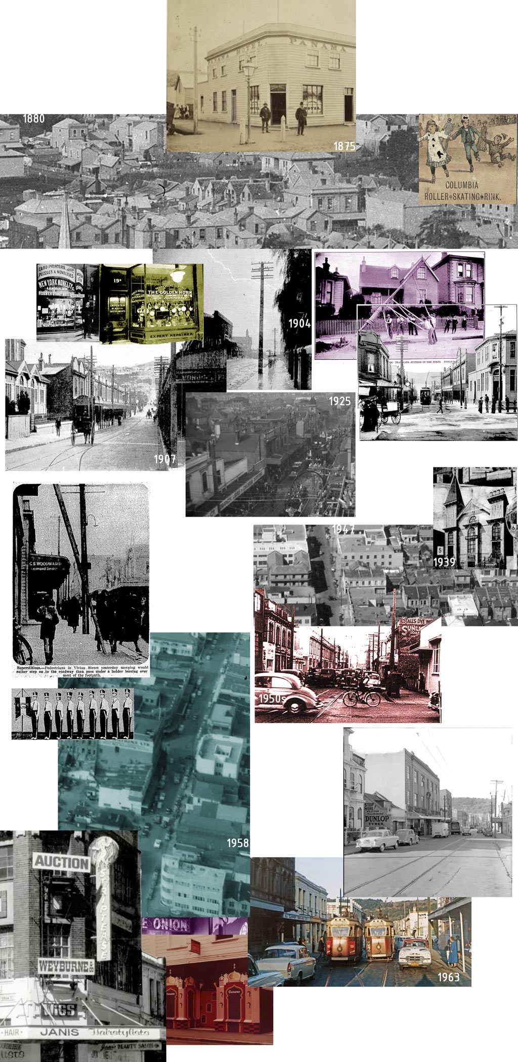
Vivian street composite
Wellington was not meant to be where it is, and its narrow streets are a result of a hasty shift from the Hutt Valley in 1839. They didn’t have enough space to lay out the 1000 town acres that they’d sold to settlers, or the 110 they’d promised to local Māori, so they had to make the streets in between these acres as tight as they dared.
The area between the western terra firma and Mount Victoria was a swamp, widening to a lagoon in the south. It was laid out anyway, with poles, except for the worst affected areas which were designated as a canal and basin. Then on 23 January 1855 a great earthquake lifted the whole region by 1 to 5 metres. The basin was now dry land.
“Shortly afterwards the vegetable matter in the swamp made a road for itself and floated down into the bay – a moving bog – leaving the present Cambridge terrace reserve.” New Zealand Mail, 5 July 1905, Page 17
Kent and Cambridge Terraces became an accidental north-south boulevard, outsized in relation to surrounding streets and its own importance. Running in a straight line, Ingestre Street, Vivian Street and Pirie Street became the only east-west axis through Te Aro.
Owners dealt with the large town acre blocks in different ways. Some farmed them, others built a single large house, and others developed them, or sold them on to people who would (a great great grandfather of mine was one of those developers). There was no consistent density. The subdivided blocks were bisected by dead-end roads. Some larger houses faced Vivian Street, while down the alley cheap and tiny houses were built. These came to be known as slums.
As the decades passed, the increasingly squalid and disease-ridden precinct became a less appealing prospect for homeowners, and undivided blocks lent themselves to industrial and entertainment uses. The Columbia Roller Skating Rink landed in the 1870s and, partly thanks to the city’s only horse tram route passing by the door, stayed popular with the young set for decades.
The trams made Vivian Street easily accessible from all corners of the city, and so it became an appealing location for industry. The opening of the broader electrified network in 1904 meant that people could live further away and still get to work quickly, leading to a boom in housing at the extremities. Miramar, Seatoun, Island Bay, Karori were all serviced by the new trams. Vivian Street was no longer at the back of a small city, it was at the crux of a growing one.
Also arriving at about this time were Whittaker’s Chocolate factory and the dens of ill-repute that would make Vivian Street the city’s main red light district for a century.
It was a lively if not a pretty street. It’s width left no space for trees or furniture. The city fathers tried to widen it in the 1920s, to fit two tram tracks, but the duplication stalled, so today it stays at 9 to 10 metres kerb to kerb, 14.1 metres (or 70 links) overall. It’s tiny. By the 1930s the people living in the suburbs that had become accessible due to tram networks wanted to drive to town, it being so fast and convenient. Cars also meant that they could live even further away from the smelly city, leading to housing and industry expansion in distant Hutt Valley.
In 1936, former mayor Mr G. A. Troup dreamt of a time when the car could have a clearer run and Te Aro would be cleaned out.
“Something must be done to obviate this congestion… Once Taranaki and Buckle Street are widened the whole of Te Aro flat would be ring-fenced by roads 80ft. in width… In the whole of Te Aro flat there are some 70 lanes, alleyways, blind streets and narrow streets. To remove these — which may be characterised as the darkest blot on Wellington city – is a task worthy of the stoutest-hearted..” Dominion 18.05.36 p5
From this time through to the 2000s, it seemed that any old street was game for widening or realignment. There has never been enough space for traffic. The expansions were an excuse for slum clearance, stimulated new development, and provided more space for cars to sit while stuck in traffic. For pedestrians, those streets – Taranaki, Willis, Victoria, Arthur and Karo to name a few – are not pleasant places to traverse or linger in. They have had a ringbarking and stultifying effect on the blocks south of Vivian Street – which are not what they once were.
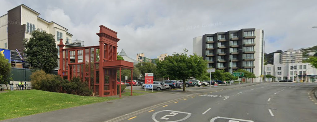
Regan Gentry’s Subject to Change sculpture on Karo Drive (2007). StreetView 2024.
In a compact and windy city pedestrians prefer to frequent streets that are compact, slow and safe. But needs must. The city’s movers and shakers, including my grandfather, wanted to get about in automobiles. The Bank of New Zealand picked up on the desires of its customers to live in their cars and installed a drive-in bank on the corner of Vivian and a now-widened Taranaki Street. The old trams were by now just just anachronisms, getting in the way.
“The tramcar, despite its excellent record and many advantages, is at its worst in the streets of a city such as Wellington, where there is a persistent desire for something more modern.” Transport loan application, 1954 link
In 1964 the trams were shown the door, replaced by electric trolley and diesel buses. Half a century later in 2017, after decades of neglect, the regional council literally pulled the plug on its trolley buses. The lines were pulled down and diesel buses took over from them, removing the last vestiges of the tram network so many other cities were trying to reinstate at great expense.
In the Sixties, my grandfather Bernard fought hard against plans for a foothill motorway that would run north south through the city, severing the CBD from Thorndon and Kelburn, and disinterring hundreds from the Bolton Street Cemetery – including his family. Bernard’s alternative plan, published in the Evening Post in 1959 and 1960, was also of its era – an elevated expressway over the top of buildings abutting the quay roads. Well it seemed to work in Sydney.
“1988, being around the corner wheeling a secondhand swivel chair along the street with a couple of student friends when a bomb went off in the Wellington Trades Hall in Vivian Street. Two of them walked in to find Ernie, the caretaker lying in the hallway, killed.” C
The American-designed foothills motorway was half-built by the late 70s when a tanking economy and high oil prices saw its curtailment. After some messy urban surgery the shortened motorway spilt cars in and out of Ghuznee and Vivian Street, two skinny inner-city streets not set up to terminate a motorway.
The population of the area around Vivian Street tripled from 1996 to 2019, new apartments and townhouses attracting many students and young workers in services industries like IT. They could walk to university or to work through increasingly interesting streets dotted with cafés, bars and quirky shops. Cuba Street was the hub – a part pedestrianised strip abounding in life. It all came to a shuddering halt in 2020 when the pandemic arrived and its associated privations. Since then the population has declined, and retail along with it. A perfect storm rolled in over the next few years, with rates and rents increasing as jobs began to disappear. Cuba Street has been so hard hit that some wonder if it’s reached a point that makes recovery impossible.
“Vivian Street? The red-light district with its strip joints, brothels, Carmen, later Peaches & Cream, the intersection of all that passed through. Music venues too, and the home of EX 23 (post-punk leather bags and belts etc) in the building on the corner of Viv and Cuba Sts.” G
Efforts by local government to reinvigorate Te Aro, and Wellington City in general, floundered. Elaborate plans had been drawn to reinvent Wellington as a people-friendly place, with lots of sketches of bicycles and trams and cafe tables. Years of work went into “Lets Get Wellington Moving” (LGWM), a $7B project aiming to improve life for the city’s inhabitants and to address climate change. The main plank and cost item was a rapid transit system. As the reports piled up authorities bickered and costs escalated. People (mainly business groups) started to promote the radical concept that the status quo was better than this farrago.
In 2023, with ears to the ground, the newly elected National and ACT parties saw to it that LGWM was scuttled and introduced policies to return cars to their rightful position as the apex predator at the top of the transport pyramid. Reactions range from “just get on with it” to “what a colossal waster of money and opportunity”.
SH1 Improvements
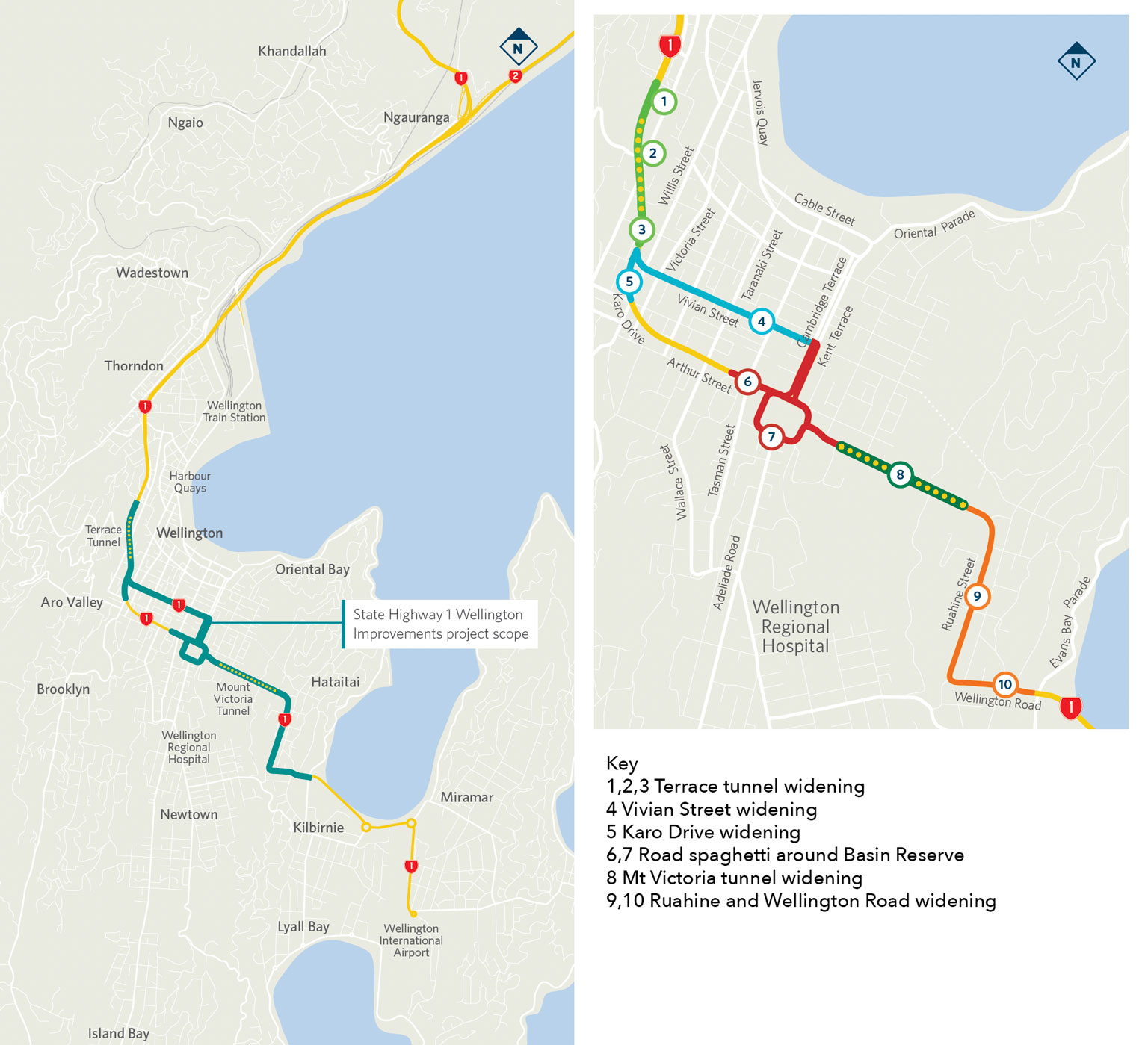
SH1 Improvements project scope map. Extract from NZTA Investment Case Summary.
“People live in places, power rules through flows.” Manuel Cassell, 1989
The government has been rewriting the rule book to allow fast-tracking of a proposal to add more tunnels and to widen State Highway 1 in Wellington, “so Kiwis can get where they want to go faster and safer”. Doing so “drives economic growth to boost incomes and unlock land for thousands of houses.” The project has no time for proofreaders – it will “unlock growth through Te Aro and the Basin Reserve to support economic growth, boost productivity and increase connectivity”.
The concept design brochure, released in November for hurried community engagement – specifically with drivers – shows duplication of the Terrace and Mount Victoria tunnels, adds a lane to Vivian Street and calibrates its intersections for maximum flow. It also makes a spag bol out of the Basin Reserve surrounds. All for about $4B. It’s part of a nationwide project called Roads of National Significance (RoNS) that the Nationals kick back into life like an old Masport whenever they’re in power.
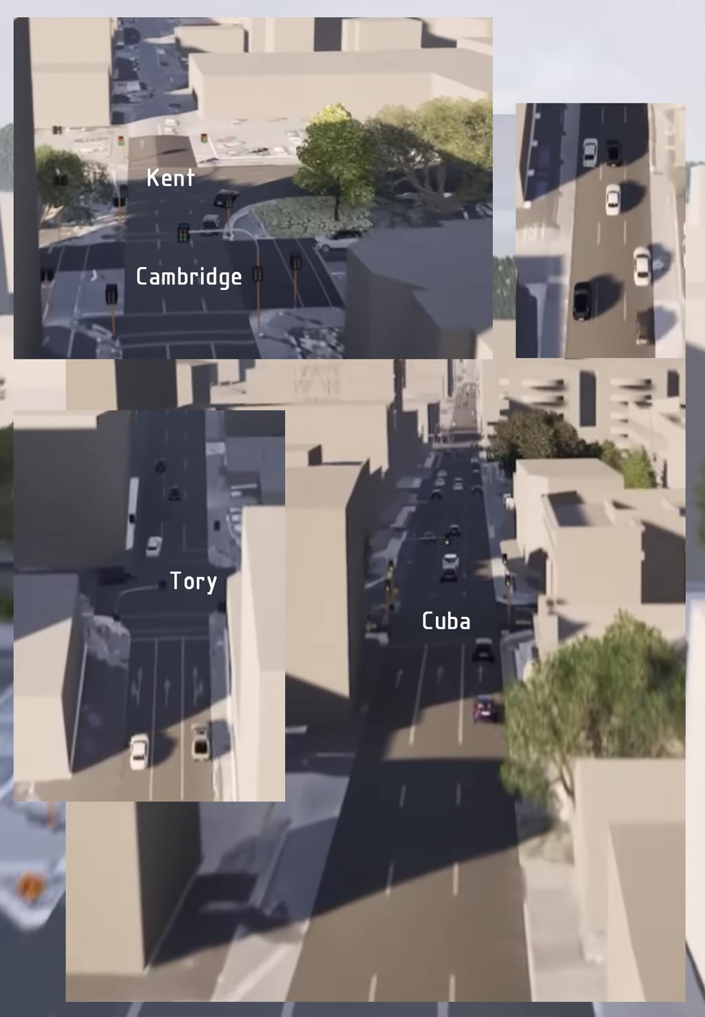
Screengrabs from NZTA SH1 flyover, 2025
The concept video is not interested in the quality of place. It is a fly-over rather than a fly-through. The buildings are a grey background, there are no pedestrians, no clutter, cross streets are almost invisible. There is virtually no traffic either – despite it being late afternoon. Vivian Street, reduced to a conduit for through traffic, traverses a city that looks dead.
The cars have a dream run, though I did notice two cars tailgating 5 metres behind the cars in front. That’s a bit of a concern as I timed them all going full blat at 90kph down Vivian – lucky there are no red lights or stray pedestrians for them to brake for. When they race to the end of Vivian Street and swing through the lights, there is an SUV planted where the two-way bike lane used to be, and the bus priority lane on Kent Terrace has turned back into a general vehicle lane. The project projects a clear idea about who they want to get moving, and it ain’t locals.
Parking will be dispensed with and shop deliveries will be next to impossible, but again needs must. The widening builds onto the current temporary solution that’s scarred the precinct for half a century already. Bereft of trees, Vivian Street’s already thin footpaths, along with some canopies, will be trimmed back to allow for a consistent road width between the gutters and no stopping lines. The footpaths are to be no less than 2.4 metres wide. Their plan shows the Vivian Street car lanes at 9.4 metres wide, or about 3.1m per lane. This is a little under Austroads recommendations (3.5m or 3.3m if you absolutely have to). When I add all this up, with an allowance for drainage, I get a total of 14.9m. Vivian Street, including footpaths, is 14.1m. I wonder where they will make up the difference?
Over in the wastelands of Arthur Street and Karo Drive, which carry SH1 Northbound traffic, they added a third lane ten years ago, so it’s a similar issue though those streets were only built 20 years ago, running a scythe through the old streets and houses. The road width between no stopping lines regularly dips well below 9 metres, with some lanes bottoming out at 2.6m.
The reason for the 3.3m minimum is that heavy vehicles are up to 2.5m wide and have wing mirrors that can add another 500mm to their width. 3.0m is not comfortable for them or the vehicles around them. Four percent of the vehicles on Vivian Street are classed as “heavy” and I don’t think this will increase if the lanes get narrower. They will stick to the alternative route through the quays.
Many cities reduce the lane widths on existing streets for safety reasons, to improve the street scape and to allow for cycle lanes. They are safer because drivers move more cautiously. The only reason here is to wedge in another vehicle lane. I think the logic is that the traffic might be moving a bit slower but there will be more of it moving through on each light phase, lessening queuing. But urban traffic doesn’t play by the rules.
This youtubing engineer guy does a good job describing how adding an extra lane might not increase a road’s throughput at all if there are any intersections in its path. The intersections he looks at max out at between 1,000 and 1,800 per direction, however many lanes they have. Vivian Street already shunts through 1,400 at peak times. Not Just Bikes, another in the burgeoning genre of urbanist Youtube channels, explains that the problem with adding a lane is that more traffic is induced, negating any time savings brought about by the extra lane, and often slowing it further. It’s not new science, but still this proposal wants to have its cake and eat it. It wants faster traffic and more traffic. The government dreams of 2,000 more people driving through its congestion-busting roads in the near future, including an extra 300 on Vivian Street in the morning rush.
Walking
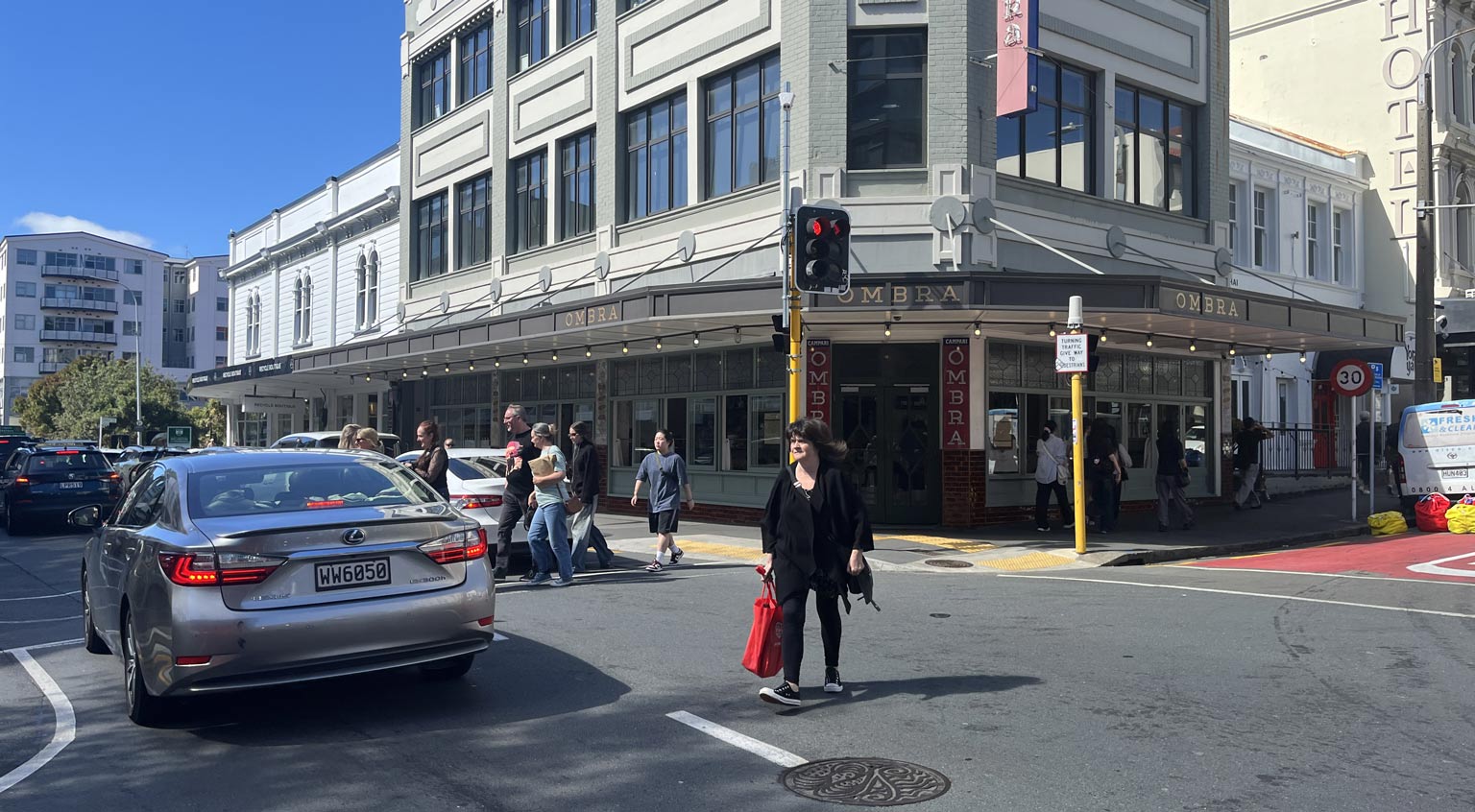
Vivian Street at Cuba Street, C. Walker 2026
In a March 2016 survey (PDF p28) for LGWM, 800-1200 people were counted walking across Vivian Street at Cuba Street, each and every hour from morning to evening. This is only one intersection along Vivian Street, but its pedestrian throughput is just a smidgen less than the number of cars driving past them as they wait.
The pedestrians wait a lot longer than the cars at that intersection – and this wait will increase after the new works. There seems to an assumption that car journeys are more productive than pedestrian ones, and that because cars are travelling further they need to be prioritised over people walking shorter distances – even if some of those people have just stepped out of their cars. Gain a minute here, lose it there.
People push a “begging button” and wait, sometimes for minutes, until the traffic lights allow them to cross. Frustration levels grow, especially if they are still waiting after all the cars have passed. It’s then that some make the rash decision to disobey the crossing signal, at risk of financial penalty and an early death. There will be more rash decision-making and more injuries. Injuries are not only costly but cause delays to traffic.
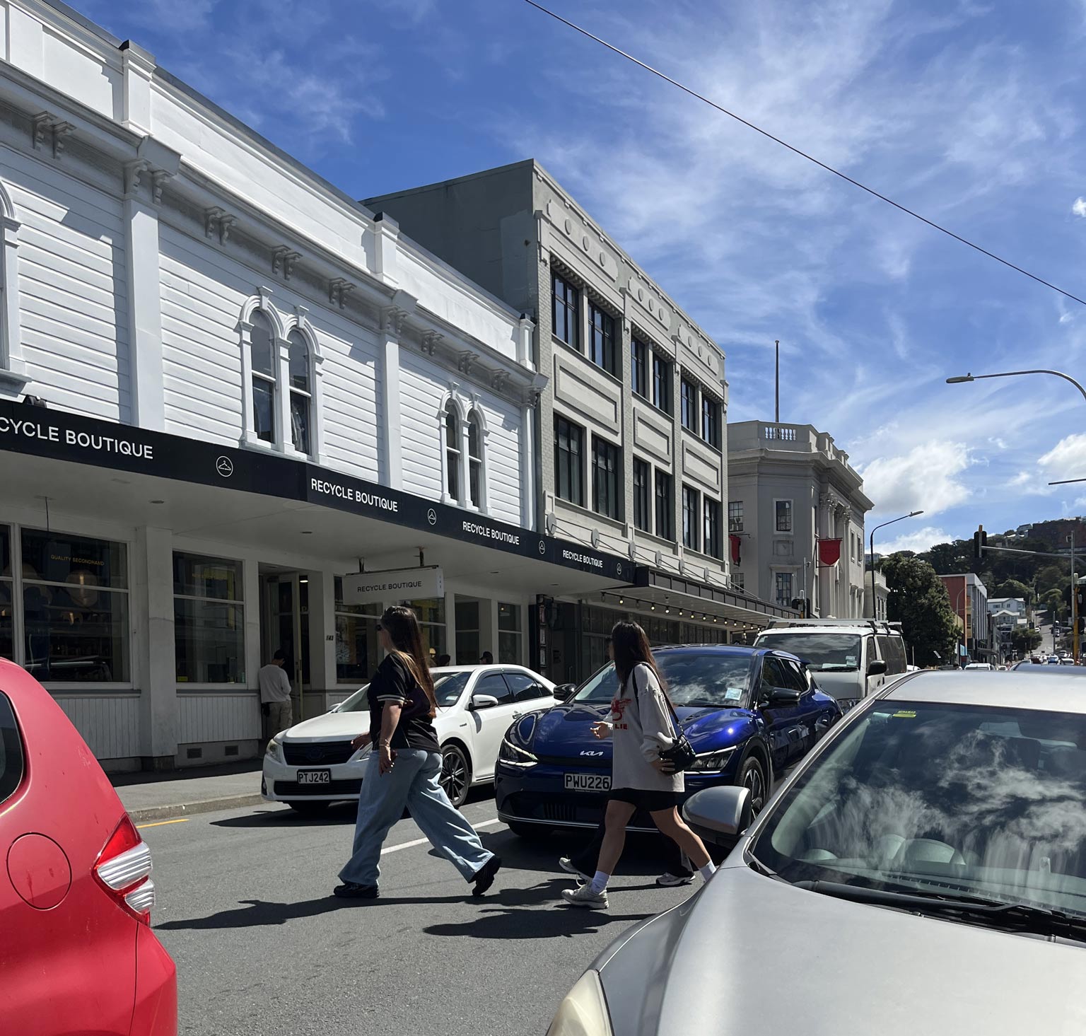
Vivian Street, C. Walker 2026
Pedestrians need some sort of buffer to traffic, as they’re going to lose footpath width and parked cars. The junctions at Vivian and Cuba Streets, and also at Tory Street, have footpath extensions to allow more people to wait without blocking other pedestrians, and to make their crossing shorter and safer. These will go. The 2.4 metre minimum footpath width might sound reasonable, but is well under recommended guidelines for such a street (3.9–6.5m including an on-footpath buffer).
As it is now, Vivian Street does not make a good highway. Numerous small streets and driveways intersect with it, venues spill out tipsy people onto thin footpaths, and people will not walk 100 metres out of their way to cross the street. 21% of the the 843 road crashes with death or injuries (2014-2023) in Wellington City occurred on State Highways managed by NZTA. Vulnerable road users accounted for 46% of deaths and serious injuries in the city. Most of these injuries occur at intersections. On Vivian Street, all the deaths and serious injuries occurred at intersections, all but one in the eastern half of the street, Tory Street being the main culprit. Minor injuries occurred the whole length of the street.
The next logical step by traffic planners is to fence the edge of the footpath, along the full block, to protect pedestrians… but also to protect traffic flow. But there might be some side effects.
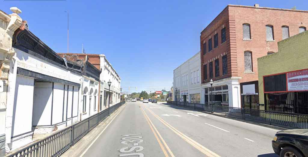
Bamberg South Carolina’s dead main street / U.S. Route 301. Fully fenced for the protection of non-existent pedestrians.
At its root, the new project prioritises through traffic at the expense of the local population. This is nothing new, in fact it’s a decades old tradition. But it will be the the local population that subsidises it, far beyond any tolls collected. More on that when in part 2 (upcoming).
Posted by Peter on 28.06.26 in urban planning
tags: cars, freeways, public transport, streets of our town
comment
Commenting is closed for this article.