The missing link
The term “missing link” was originally applied to old fossils. It’s fitting that it is now being used to describe Melbourne’s East West Link. This little project has been floating about since the 1950s, but in it’s current form it can be traced back to a suggestion from Premier Jeff “the quiff” Kennett in 1999. It’s been looked into since, but has always been a political impossibility, and a waste of money… until now. The planets are aligning and Dr Napthine and Tony Abbott can see the project’s “electoral” potential. As long as it’s sold in the right way to the right voters. These voters live in Melbourne’s East, in some of the most marginal electorates in the country. They’re been tempted with a big carrot – a faster run down the Eastern Freeway in the morning rush. We’re told that this run has slowed down 20kph since 2001, which is true, but only because there was a short-lived speed spike in 2001 after the opening of City Link.
Once they’ve had their leisurely drive on the Eastern, most of our drivers will land straight back into the usual traffic jams. There are no tunnel exits along Alexandra Parade, where most drivers continuing beyond Hoddle Street turn North or South. It’s the lucky one in 5, or 1 in 10 depending on where you read, attempting to journey beyond Royal Parade who will now have the option of driving through the $6 – $8B tolled tunnel, saving quite a few minutes. The lucky tunnel drivers may be a little intimidated when they realise they’ll be sharing these tunnels with the B-double and B-triple trucks for whom this expensive short cut is really being built (an East West planner told me so). Imagine what it would be like to drive between two of these road beasts in a tunnel…
A B-triple up close
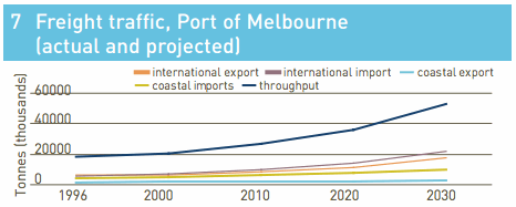
These trucks currently haul their freight between the ports and industrial hubs using CityLink, the Monash, and Westgate bridge. The growing number of container trucks enables our collective preference for cheap imported goods over locally-manufactured ones. By weight, imports at the Ports of Melbourne far outweigh exports. Most are from China, and many are cars. Most attract no import tariffs. Demand is straining the ports’ capacity to deal with its cargo. The East West Link’s purpose is to redistribute some of this load from CityLink and the over-stretched Westgate Bridge. It’s odd that they’re starting at the Eastern end, as the Westgate is over in the West.
Just before they left office in 2010, Labor announced that West Link construction would start by 2014, though they hadn’t found the money. The newly elected Liberals swapped the start point over to the Eastern end without much explanation. It’s pretty easy to guess the main reason…
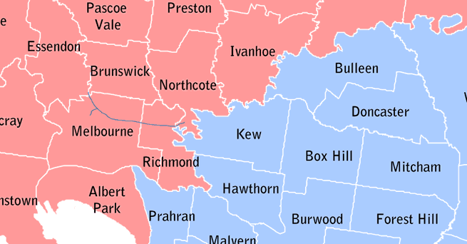
_2010 state election results map showing East West Stage 1 (wikipedia
You’d expect oddities like this to be made sense of in the business case. But the short form business case issued to Infrastructure Australia is a promotional brochure containing some rather hopeful numbers and, oddly, lots of photos of trams. The most optimistic number, and the most important, is 1.4. This is the benefit-cost ratio that pushes East West Link just ahead of the Metro Rail project (1.2). West Link was only 1.16. Quite how the benefits came to be this high isn’t explained. The clue is in the small print. This BCR contains within it “Wider Economic Benefits” for the state. This is naughty, as the BCR required by Infrastructure Australia is meant to be for the project alone – otherwise it gets very difficult to compare apples. Allan Davies at Crikey has found that the figures don’t even add up. The case was submitted after the deadline, after announcing that East West would proceed, and after securing a $1.5B starter fund pledge from federal opposition leader Tony Abbott. If the Coalition win next month’s election, Infrastructure Australia has been bypassed.
Infrastructure Australia’s current head honcho is Rod Eddington, who under a different hat wrote the influential 2008 report recommending the East West Link. He knows more about the big picture than the state government, and he well knows what’s wrong with this version of his project – the more important Western end has been neglected, and his integrated rail improvements have been omitted completely. That last one will be particularly grating for Eddington, as he went to great pains in his 2008 report to point out that for Melbourne’s transport system, no action on rail was not an option. He found that suburban rail improvements cannot start until the CBD has the capacity to absorb the extra trains, which is what Metro Rail is there to do.
In mid August, Premier Napthine finally got behind Metro Rail, though he did say he didn’t like the name. Tony Abbott however remains against it: “We will not be committing to the Metro Rail scheme, I’ve made that absolutely crystal clear”.
Based on the costs of Perth’s rail line down the middle of the Kwinana Freeway, a rail line running from Victoria Park along the Eastern’s median to Doncaster could be built for $894M. An extra $300M would take it through to Parkville and Metro Rail, and provide the only East West rail in the city. Instead parts of this median will become asphalt, limiting future rail options.
“Manningham has a population comparable with Geelong, but while Geelong
has a frequent train service to the city with 160 kilometre an hour trains,
Manningham residents have no such service. They also face a longer journey by bus if they choose not to use their cars.” Professor Bill Russell, Unimelb ABP
Then and now, across Melbourne’s road network.
| 2001 | 2011 | |
|---|---|---|
| Population | 3.5M | 4.1M |
| Vehicle kms | 23.5 billion | 27.5 billion |
| Truck kms | 1.7B | 2.1B |
| Avg. car speed, AM peak | 37kph | 35kph |
| Avg. tram speed, AM peak | 15.2kph | 15.0kph |
| AM rush duration | 1.75 hrs | 2.75hrs |
| People per car, AM peak | 1.20 | 1.12 |
| Road traffic increase | – | +20% |
| Public transport increase | – | +60% |
{ sources: vicroads and charting transport }
Traffic (per day, both directions)
Westgate Bridge: 170K, growing at 2.1%
Eastern Freeway at Hoddle St: 135k, growing at 1.8%p.a.
{source: The Age }
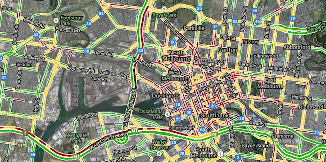
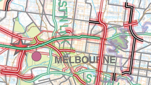
This project will increase traffic on the Eastern Freeway, providing an alternative to the M1. Here’s a live traffic map from right now, at 6.55pm on a Friday illustrating why this might be required.
Google Maps + traffic overlay
Google Maps now allows you to display average traffic flows from any time of the day or week. It’s a powerful and accurate tool that lets us take a closer look at the Eastern Freeways traffic problem. The “slow = red” problem on the inner Eastern is a little hard to find, as it only gets bad between 8.00 a.m. and 8.15 a.m. from Monday to Thursday. I’m sure those stuck in it will have a different perspective.
So who is stuck in it? Recent monitoring tell us that 80% of morning car commuters are travelling alone – this percentage has increased about four percent since the government discontinued car pooling initiatives. 70% (not a typo) of freeway drivers in the morning rush aren’t going to work, they’re dropping kids at school, or going to the gym. 17% are off to the shops or to play, compared to 3% 35 years ago. The current government is keen for all these drivers to stay in their cars as they offer no demand-side initiatives to lower vehicle use, their sole focus is to supply more road for them. This only buys a little more time.
There is a small, quietly announced element of the East West Link that doesn’t defy common sense. Traffic lights and variable speed limits are to be installed along the Eastern Freeway. This will relieve congestion, for a while. This is about all that is being done that’s of direct benefit for the bulk of commuters driving into town. Outbound drivers will get a new bridge to drive over or under. It won’t improve travel times a jot but it will be a lasting “cheese sticks” monument to Premier Napthine.
They’ve already tried traffic calming measures on the M1 (Monash), as part of the recent improvements. The tollway flowed more freely for a while – now it’s back to where it was. This is the way it works – make a road faster and more people will opt to use it instead of arterial roads or trains, slowing it back down till it is barely tolerable.
A government that says it’s broke and can’t fund TAFE is throwing all its coins (and more) into a new road that will benefit few for not very long. Infrastructure Australia classifies it as a freight project yet it’s being sold as a commuter congestion fixer. In committing to this, other more urgent projects are put in the back seat (post 2020). It’s this last effect that makes East West Link a good example of a vote-driven government that is blind to the big picture.
This brief summary of events hardly scrapes the surface. There is more to this argument than the “trains vs. tolls” placards tell us. Being a fat line through the inner North of Melbourne, the East West Link touches on many issues beyond its immediate neighbourhood. I believe they are all important and affect how we will dwell in this city in the future.
I have brutally compacted some of the other chapters of the East West Link story below. These are extracted from a 6000 word post that got a little out of control.
- The often stated 20km speed drop on the freeway over the period 2001 to 2011… is not. The 2001 figure spiked, probably due to the opening of CityLink. Less dramatic figures are found for the period 2002 to 2012.
- Traffic estimates for the new tunnel (80 – 100,000 per day) would require significant extra traffic on the Eastern Freeway.
- The Linking Melbourne has private evidence that, “most of the traffic is trying to get across town”. This evidence contradicts all other reports and monitoring.
- In 2003, 37% of incoming freeway traffic turned South onto Hoddle Street. Using freedom of information laws, The Age obtained a recent study for the government and concludes from it that, “only a small proportion of the cars, trucks and buses clogging Hoddle Street are likely to use the tunnel as an alternative if there are no off-ramps to the city.” There are no on or off-ramps proposed except in Royal Park.
- The tunnel would reduce Alexandra Parade traffic only negligibly and temporarily as 90% of it is not making the full trip across to Flemington Road.
- Options to lessen the Eastern Freeway congestion through time-of-day congestion charges are not being examined.
- Peak hour traffic has doubled since the Seventies. The morning peak is now much greater than the afternoon peak, being heavily concentrated around 8.30 a.m. The afternoon has a double peak now due to school pickups, which generate more trips than evening commutes. Initiatives to spread the morning peak don’t exist.
- All-day traffic on Alexandra Parade has been steadily decreasing since 2002.
- The stated aim of easing congestion does not take into account unlocking latent demand.
“It is not evident that the impact of the East West Link on future traffic congestion levels has to date been adequately analysed and assessed.” Auditor General, April 2013
- Increases in traffic are driven in part by land use decisions in the outer suburbs, which do not take into account their affect on the greater road network.
- Traffic congestion’s effect on productivity is a reason for the project, yet public transport congestion is not shown the same respect. There is an assumption here that public transport can’t assist economic growth, yet the concentration of jobs can’t occur without it. The industries most favoured by this proposal, manufacturing and transport, are the only two that grow better without job agglomeration. They are also the two poorest performing industries in the country.
- The funding model for the project places the risk with the taxpayer, and prevents private operators from profiting from traffic increases. The operator, should one be found willing to accept the conditions – will build the road and then be its caretaker.
- All new transport infrastructure in Victoria needs to be assessed using the Transport Integration Act (2010) framework. The Act requires a triple bottom line assessment. This would be interesting to see…
- Making roads like this more free-flowing probably leads to a short term reduction in emissions, but this is soon cancelled out by increased patronage of the road.
- Replacing the rail easement with new lanes at the Western end of the freeway is just startlingly short-sighted. Premier Napthine says this project is about “choices and options”, but not for rail.
The Property Council responded to Eddington’s report in 2008 by saying, “We are pleased that Sir Rod Eddington and his team have adopted what appears to be an integrated approach, which does not just provide for the construction of tunnels and roads but seeks to incorporate other improvements to our public transport network, while at the same time promoting alternatives like cycling as part of the solution to our traffic woes”.
- In 2010 the government implemented four smart buses, optimisticly calling them “Doncaster Area Rapid Transit” (DART). While there is a transit lane on the Eastern Freeway, there is only a South-running one on Hoddle Street, where these buses travel. Crikey author Alan Davies writes that Transport Minister Mulder rejected a North-running one as it would require a clearway, a concept the government has some trouble with. Presently 10,700 DART customers are delayed 15 minute every evening so that 175 on-street car parks can be maintained.
- Allan Davies (Crikey) recently calculated that subsidies to car travel are equal to those for public transport, but much harder to measure.
- The argument for public transport isn’t helped by the dire state of the subsidised private system.
- The Melbourne airport CEO has called for extra lanes on the busy Northern section of the Tullamarine, saying they’ll be immediately needed if the government doesn’t progress the airport rail link (which has been set back further by East West Link’s prioritisation).
- In addition to the hundreds of private properties that will be flattened in Clifton Hill, Kensington and Moonee Ponds, several public parks, creeks and wetlands are heavily impacted upon.
- An historic hand-cut railway cutting (GSA ML 69) in Royal Park, used for 120 years as a site for geological tuition, will be removed for the tunnel head. Also the hill behind it.
- The main sewer for the North East runs along Alexandra Parade and Princes Street. It is a historic structure and will mostly be left intact by the tunnel, meaning that the tunnel will be built beneath housing on the North side of Princes Street.
- The diesel truck-laden City of Maribyrnong, factored out of this project, has more than 20 cases of child respiratory illness requiring hospital admittance per capita, over ten times the figure for the Eastern suburbs.
- The government is under pressure to find jobs to replace those vanishing on Peninsula Link and the Western Ring Road upgrade, but there appears not to be the same urgency to find jobs for rail builders once the Western regional rail upgrade is complete.
- Eastern drivers will benefit from the next project in the pipeline – to connect the Eastern Freeway to the Western Ring Road, probably going under the Bulleen wetlands.
- In 2009 the Labor state government voted in the Major Transport Projects Facilitation Bill, which allows the usually check and balances to be bypassed in the interest of cost and efficiency.
The RACV, in response to Eddington’s 2008 report, “Melbourne’s transport network remains incomplete and there is no comprehensive transport plan for the next 30 to 40 years to provide a context and direction for ongoing developments.” They supported an East West tunnel as part of a multimodal solution, major components of which were to strength cross-town public transport and improvements to rail freight.
VicRoads wet dream for 2040 – six lane arterial roads connecting a whole lot of “missing links”.
Factual references available on request – there were too many to add.
Posted by Peter on 20.08.13 in urban planning and cities
tags: cars, freeways, public transport, streets of our town, transport
comment
Great, if deppressing stuff. Sydney road network history shows that roads authority wet dreams have a habit of coming true.
by Ross Turnbull on 20 August 2013 ·#
Whereabouts is the diagram titled “VicRoads wet dream for 2040” from?
by Marcus Wong on 22 August 2013 ·#
Marcus, ‘tis from here: http://www.theage.com.au/pdf/Melbourne2040.pdf – a 2012 leak.
by peter on 22 August 2013 ·#
Wonderful analysis peter – so basically its to please truck operators and outer eastern suburban voters – though does anyone know whether those voters actually want it in its current form ? Only helps drivers get to airport or footscray quicker.
The thing that bugs me – besides the huge cost wrong priority and not only no rail but making it harder – is that the design is messy indeed, surely they looked at other possibly better designs / routes, but I guess we will never see them.
Cant help redesigning it in my head for instance having the main tunnell continue under the park and flem road and surface adjacent to exist citylink furtger south. More expensive but so much neater. And no new freeway even closer to that huge new apt tower and flem commission high-rise- theres already a sound barrier so if new one is even closer will it be totally enclosed ?
I wonder what paramters they used – probably least cost and least property purchase, so it comes out in the park (free space) rather than further away, also explains the only exit being in the park (with a crazy sunken intersection where one in and one out ‘ramp’ cross – traffic lights ???). Guess they thought all that use of parkland could be brazened out, but cut and cover in the park couldnt, though that would make far less expensive.
I feel like sketching out something thats really more of an arterial road with only a short tunnell under the cemetary – all thats needed is three continuous lanes all along, removing bottlenecks, make it faster tbrough traffic management rather than huge tunnell – widening elliott ave to three lanes each way would prob use less park than the current design !
So its all a fait accompli, instead of the commjnity being led through options – even in the us they often have hearings to discuss options. Its like moscow here – you will be purchased theres no options full stop.
by rohan on 14 September 2013 ·#
I’m interested to know why they would choose to use public financing for such a project, rather than a PPP delivery or similar.
If they were able to involve contractors now (and in accordance with state guidelines for construction projects, encourage innovation) there could be a completely different link, which caters for freight, it doesn’t destroy as much green space, it could offer a rail corridor, it could acquire more land and create new green spaces to offset losses, etc. There are plenty of possibilities to deliver a road for freight, and benefit the community as well. The current proposal is elementary at best.
The closed door nature of the process so far, as Rohan has pointed out, has been unsavoury and I feel will cost the state dearly in the future.
by Nick on 10 June 2014 ·#
Commenting is closed for this article.

